Top 15 Apps Similar to geo Location Marker

Geolocation 2.1.055
You can also check your geolocation by IP address now!An all-in-one tool for comparing the reverse-geocodingresultsreturned by the following engines:1. Google2. Yahoo3. OpenStreetMap4. MapQuest5. Bing6. FourSquare7. China - BaiDu8. China - Tencent Maps9. China - Jiepang10. China - SoGouKeyword: Geocoder, Reverse Geocoding, My Location
Geo Tracker - GPS tracker 5.1.5.2972
You can find answers to most commonquestionsin the FAQ section of mywebsite:https://geo-tracker.org/faq/?lang=enIf you're looking for an excellent gps tracker, if you're a fanofaction sports and long distance travel - this app is foryou!Record tracks of your trips and share them with your friends!Geo Tracker can help:• making the reverse journey in an unfamiliar area withoutgettinglost
• tell your friends how to repeat your route
• use someone else's route that is stored in GPX or KML• mark important or interesting points of your trip.The application is able to record, even when switched off. Verylongtracks could be recorded without problems - you are limitedbystorage memory only. Recorded tracks are saved in GPX orKMLformat, so they can be used in certain applications such asOziExplorer or Google Earth.When showing track on the map, the application keepsdevicebacklight, which simplifies track navigation usage.Geo Tracker is based on public API of Yandex.Maps, so in tripsoverRussia and CIS countries you'll have the most detailed map ofthearea.Application can calculate track statistics - boldly show offyourachievements to your friends :)Geo Tracker calculates:• Max & average speed on the track;• Time and average speed moving;• Max & min altitude, altitude difference;• Vertical distance, ascent & speed;• Min, max & average slope;There are also some fine charts of speed & elevation;If you have a proposal how to enchance the application or facedsomeproblem - please feel free to contactme:support+gplay@geo-tracker.org. Thanks!Useful tips & tricks to solve common GPS issues withyoursmartphone:• If you start the tracking please wait with recording youractivityuntil the GPS signal is found.• Restart your smartphone and make sure that you have "clearview"of the sky before you start (no disturbing objects likehighbuildings, forest, etc.).• The reception conditions are permanently changing because theygotinfluenced by the following factors: weather, season,positioning ofsatellites, areas with bad GPS coverage, highbuildings, forest,etc.).• Go to phone settings, choose "Location" and activate it.• Go to phone settings, choose "Date & time" and activatethefollowing options: "Automatic date & time" and "Automatictimezone". It may occur that it takes longer until the GPS signalisfound if your smartphone is set to the wrong time zone.• Deactivate the airplane mode in your phone settings.If none of these tips & tricks helped to solve yourissues,deinstall the app and reinstall it again.Be aware that Google uses in their Google Maps app not only theGPSdata but also additional data of the current locationfromsurrounding WLAN networks and/or mobile networks.


CHI Geolocation 1.0.10
CHI Geolocation is very useful forthosepeople,who travel a lot – it helps them to find a way in newcity.The Appidentifies user’s current position and allows tochoose thenearestHotel, Hospital, Police Office, Subway or BusStation, CaféorRestaurant.Smartphone owner select a category and then he can see allthelistedplaces on the Map. He can look through them, choosethemostinteresting and create a route from where the user standstoallpreferred objects.Navigation is very simple thanks to user friendly interface,evenakid can manage this.Advantages of CHI Geolocation are obvious:- you will never get lost, as the App works worldwide;- you will never stay hungry or roofless in any foreign city;- you can choose the best route and save your time;- explore nearby places before going sightseeing;- you can check your activities on statistics.With the help of CHI Geolocation you will find yourwayquickly.You can always rely on it!--------------------------------------------------------------------NOTE:- This application needs access to device's currentlocationusingGPS or Network (WiFi/Mobile Data).- Accuracy of location depends on the device,selectedlocationprovider and your location (it might not workproperly witha lowsignal).

Maps GPS Places 1.8
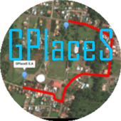
Registren la empresa donde trabajan:GPlaceS surgió como un proyecto que busca aprovechar al máximolalocalización GPS y Google Map v2. Si eres un empresario osoloalguien que desea registrar una cuenta para una empresa ygestionartodos los servicios que ofrece dicha empresa, ya quetendrás elcontrol de tu cuenta y de los productos o servicios quepublicasserán administrados por el dueño de la cuenta.Pero si eres un usuario que desea calificar o votar porlasempresas que se encuentran registradas, podrás registrar unacuentade usuario la cual te permitirá calificar a lasempresasregistradas desde 1 a 5 estrellas y muy pronta, podrásopinar sobrelas empresas que calificas.GPlaceS se encuentra en fase beta, es por ello que concadapersona que registre su empresa en nuestra base dedatos,lograremos una aplicación estable y con muchos lugaresdondeescoger. por lo que pido a las personas que votan con unaestrella,piensen primero que esta aplicación tiene sus bases dedatosintactas y que entre mas empresarios conozcan esta app,masopciones de búsqueda exitosas tendrán. GPlaces se encuentraendesarrollo y por el momento las cuentas son gratis.Características*Registrar cuenta gratis*Localización GPS de tu empresa en cualquier parte delmundo.(Google Map)*Registro de varias categoría para tu empresa (Hotel,Restaurante,Soda)*Registro de productos o servicios*Estado de empresa open/closed*búsqueda por categoría, distancia, cantidad de resultadoycoordenada.*Calificación a lugares visitados*Información de la empresaMuy pronto se podrán comprar productos y servicios desde lamismaaplicación.Record the companywherethey work:GPlaceS emerged as a project that seeks to maximize theGPSlocation and Google Map v2. If you are a businessman orjustsomeone who wants to register an account for a company andmanageall the services offered by the company, as you will havecontrolof your account and the products or services you post willbeadministered by the account holder.But if you're a user who wishes to qualify or vote forthecompanies that are registered, you can register a useraccountwhich will allow you to qualify from the registered from 1to 5stars and very prompt companies can review the companiesthatqualify.GPlaceS is in beta, which is why each person registeringyourcompany in our database, we will achieve a stable and plentyofplaces to choose application. so I ask people to vote with astar,think first that this application has data bases intact andthatthe more entrepreneurs know this app, more options havesuccessfulsearch. GPlaces is under development and currentlyaccounts arefree.Features* Register Free Account* GPS of your company at any location in the world.(GoogleMap)* Record multiple categories for your business (Hotel,Restaurant,Soda)* Registration of products or services* Company State open / closed* Search by category, distance, number of resultsandcoordinate.* Rated to places visited* Company InfoSoon be able to buy products and services from thesameapplication.


GPS Map 27.0.7
GPS Map is a free, advertising supported app that allows you todoawesome things with a map powered by Google on Android devices.Fora price, you can get GPS Map Pro which is identical withouttheadvertising banner.Activities are organized into the following categories:* Search - Find new Placemarks by address, or coordinates.* My Location - Center or mark your place quickly, toggleReal/Mocklocation, Search nearby, and Share your location.* Layers - Allows you to toggle the visibility of MyLocation,Placemarks, Satellite, Traffic, Track, and Routelayers.* Placemarks - View list, Center, Change location, use asMocklocation, Navigate to, Route to, Search nearby, Street View,andShare* Routes - View list, Change color, Details, Hide, ShowandShare* Tracks - View list, Start/Stop Recording, Change color,Graph,Tour on Google Earth, View at Human, Land, and Plane speed,andShare* Images - View list, set Default for Marker, Import as aMarker,Import location from Image* Markers - View list, Edit/Delete/Hide/Show groups ofPlacemarks,Markers created for each Import* Compass Mode - All visible layers rotate instead of MyLocationarrow rotating towards north* Copyright - All the legal copyright and disclosure stuff* Data Management - Import/Export/Manage data* Help - A quick introduction, the FAQ, and links to otherhelpfulcontent about GPS Map* Preferences - Adjust update time, long press time, thevisibilityof various items and featuresUse almost any image from your Camera, Gallery, or file browsingappto create a Marker for a Placemark on the map. Imagescontaininglocation information can be imported as Placemarks withtheir imageas the Marker on the map.GPS Map has the following features:* Easy to search for a location by address, placemark name,orlatitude, longitude.* Import/Export your Placemarks - GPSMap GPS, Garmin CSV,GeocodeGEO, Google Earth/Google Maps KML,GPS Exchange GPX filesandTomTomASCII* Imports the location and image from a photograph to createaPlacemark on the map with the Image as the Marker* Able to view Placemarks, Routes and Tracks with GoogleEarth* Able to be taken to Google Street View for a Placemark(ifavailable)* Able to use Placemarks to start a navigation app likeGoogleNavigation* Export to Google Drive Fusion Tables with an activeGmailaccount* Creates Tours for Google Earth based upon your recorded TrackWorks best with:* Google Earth, Google Maps, Google Street View installed.GPS location service enabled.Visit https://sites.google.com/site/wrightkeith/gpsmap/formore information.

Quechua Tracking 1.5.1
Quechua Tracking, a new hiking experienceonyour smartphone.Quechua Tracking is a must-have app, providing essential featurestoenable you to track your hikes.GPS Tracking and permanent geolocation feature for your safety,arecord chart and option to create a hiking journal that youcanshare with your friends etc. Thanks to Quechua Tracking,yoursmartphone can be converted into a genuine outdoor GPS and cankeepa record of all your hiking experiences.Localization system and safety:Using the collaborative map, OpenStreetMap-Landscape, Quechuaallowsyou to find out your GPS position, in real time, anywhere intheworld.This map is updated with new details every day, thanks tothecontributions of internet users. It also has specialoutdoorgraphics (with contour lines, trails, vegetation,ski-lifts,etc.)Zoom available up to a scale of approximately 1/10000m (dependingonresolution of smartphone)If you wish to provide rapid and accurate information totheemergency services about your location, in the event ofanincident, you can simply send a screenshot of your position onthemap by text or MMS.If you're worried about poor network coverage during yourhike,Quechua Tracking includes a function that allows you to"download amap:" pay a one-off charge of EUR 1.99 (InApp Purchase)and thenyou can download, onto your mobile, the appropriate basemap forthe route you wish to take.Record chart:Quechua Tracking allows you to view your activity andyourperformances: altitude, cumulative elevation gain/loss,distancecovered, climbing speed, walking time etc. This will helpyou focusyour efforts and improve your hiking time.Hiking Journal:Start and finish points, elevation gain/loss, route, duration,speedetc. Quechua Tracking allows you to record information aboutyourtrip, combine photos and comments and create your veryownHikeBook®: a new type of hiking journal, incorporating yourfinestmemories.You can share photos taken during your hike, at any timeonFacebook™ or e-mail your Hikebook® to selected individuals.Main functions:-GPS tracking-Geolocation and tracking on OpenStreetMap-Landscape-Share your GPS position via text or send a screenshot of yourmapposition via MMS.-Downloadable map (chargeable)-"Mountain" record chart-Elevation profile-Save and share photos-Create and share a HikeBook®, a hiking journal documentingthethrill and excitement of the hiking experience


Sygic Truck & RV GPS Navigation 21.3.0
High-quality GPS navigation designed for professional drivers&their large vehicles. Trusted by 3 million drivers ofTrucks,Camions, HGVs, RVs, Caravans, Campers, Vans, Buses, Cars& manyof the world’s leading delivery fleets. Lots of smartfeatures,beautiful 3D offline maps, and easy to use interfaceprovide aproductive and enjoyable navigation experience. SygicTruck GPSNavigation is the best copilot on your routes! TRUCKSPECIFIC MAPS& ROUTING • Special routing for Truck / Camion /LGV / HGV/Delivery Van calculated for the vehicle & load. •High quality3D offline maps. Free map updates several times peryear. Maps arestored offline on your device so internet connectionis notrequired, works with GPS signal. • 3 route alternativesaredisplaying total time, distance, and elevation of the route.•Profiles for 3 different trucks. Set the parameters suchasdimensions, weight, transported material (HAZMAT), numberoftrailers, and the app will select the best route for the vehicle.•Last-mile functionality displaying restricted part of the routeina different color POIs • Millions of Truck specific PointsofInterests • Include gas stations, weigh stations, and restareas.PROFESSIONAL PLANNING & OPTIMALISATION • Advancedrouteplanning to avoid toll roads, U-turns, hazards such as lowbridges,narrow roads, or restricted areas (emission zones, schoolzones).Set preferences such as right turns or arrival with thedestinationon the right side. • Plan & optimize your Multi-Stoproute. Addup to 150 waypoints, and they will be re-arranged toachieve thebest efficiency. • Plan your route with Google Maps& easilydispatch to the app with Sygic Truck Route Sender -free extensionin Chrome and Firefox browser. DESIGNED FOR RV /CARAVAN / CAMPER /BUS • Profile configuration for RV / Caravan /Camper / Motorhome /Bus • Special routing for RV / Caravan / Camper/ Motorhome / Buscalculated for the vehicle & load. • Routesand directionsdesigned for RVs based on your vehicle size • RVspecific POIs:Campgrounds, parking stations, rest areas and moreSAFETY FEATURES• Spoken voice instructions with road indication •Dynamic LaneAssistant & Junction View • Speed Limits &Speed CamerasWarnings ADD-ONS • Live Services include Real-timeTrafficinformation + Mobile Speed Cameras Database + Fuel Prices +ParkingPlaces • Head-Up Display (HUD): Projects navigationinstructionsonto your windshield AVAILABLE MAP REGIONS • NorthAmerica • Europe(with Russia) • Australia & New Zealand •Brazil • Middle East• Africa You can test-drive Premium feature forthe first 14 daysafter installation. After 14 days, you cancontinue using the basicfeatures or upgrade to the Premium license.Also available fromSygic: Should you have any questions, pleasevisitsygic.com/support. We are here for you 7 days a week. If youlikeour app, please leave a review. Thank you for your support.PrivacyPolicy: www.sygic.com/company/privacy-policy Terms ofUse:www.sygic.com/company/terms-of-use By installing, copying orusingall or any portion of this software you accept all the termsandconditions of this agreement: https://www.sygic.com/company/eula

All-In-One Offline Maps 3.6c
All-In-One OfflineMaps offers you toaccessa wide range of maps for free.Bored to wait for maps to display? Once displayed, mapsarestored and remain available, quickly, even with nonetworkaccess.• Want more than just roads on your maps? You will findwhatyou need here;• Used to go to places with poor network coverage?Everythingwill stay available;• Used to go abroad? You won't be lost anymore;• Have a data allowance limit? It will reduceyourusage.★★ Maps ★★A lot of maps are available, including classical roadmaps,topographic maps, aerial (satellite) maps and various layersthatcan be added over any maps: OpenStreetMap (Roads, Topo),GoogleMaps, Bing Maps, USGS National Map (Hi-res topo, Aerialimagery),Worldwide Military Soviet topo maps, etc.• All maps can be stacked in layers, with preciseopacitycontrol.• Select and store large areas in few clicks.• Stored space is clear and can be easily deleted.★★ Display, store and retrieve unlimited landmarks ★★You can add various items on the map such as waypoints,icons,routes, areas and tracks.You can easily manage them using the powerful SD-CardLandmarksExplorer.★★ On-map GPS Location & Orientation ★★Your real location and direction are clearly displayed on themap,which can be rotated to match your real orientation (dependsondevice capabilities).Easy turn on/off to save battery.And also:• Metric, imperial and hybrid distance units;• GPS Latitude/Longitude and grid coordinate formats (UTM,MGRS,USNG, OSGB Grid, Irish Grid, Swiss Grid, Lambert Grids, DFCIGrid,QTH Maidenhead Locator System, ...);• Ability to import hundreds of coordinate formatsfromhttp://www.spatialreference.org;• On-map grids display;• Full screen map view;• Multi-touch zoom;• ...★★ Need more? ★★If you are a real adventurer, try AlpineQuest GPS Hiking,thecomplete outdoor solution based on All-In-One OfflineMaps,loadedwith a powerful GPS Location Tracker andmore:http://www.alpinequest.net/google-play

Falk Maps & Route Planner
Falk Maps is a reliable companionformotorists, pedestrians and cyclists. It offers functionalonlinemaps with route planning and millions of points of interestsuch asrestaurants, hotels, shopping, attractions and manymore.Features:* A whole bunch of different online cards for everyoccasion(motoring, hiking, cycling...)* Route planning with traffic jam avoidance in real time* Route planning also available for cyclists and pedestrians* Over 5 million POIs (Points of Interest) fromdifferentcategories: speed cameras, car parks, attractions andmuchmore.Please note:* During the use of Falk Maps an Internet connection isrequired(the app does not include offline maps, only the actuallyrequiredmap tiles are loaded* Falk Maps does not provide turn-by-turn navigation.Criticism? Suggestions?Please write us an e-mail to hilfe@falk.de with the subject"FalkMaps Android". We are happy for any kind of feedback.