Top 20 Apps Similar to NOAA Weather and Radar

NOAA Weather Unofficial (Pro)
This weather app is not affiliated with NOAAorthe National Weather Service. Products provided by NOAA are inthepublic domain, and this app's use of those products iscompliantwith NOAA/NWS terms of use.This app provides forecasts, animated radar, hourly forecast,andcurrent conditions, all in an intuitive and easy to useinterface.Just the information you need, provided accurately,quickly, andfor your exact location.★ "A no-nonsense approach to show weather data on your phone,butdone well and great looking" - Android CentralThis app uses NOAA point forecasts from your GPS location to getthemost localized weather available. Point forecasts are greatforclimbing, hiking, skiing, or any outdoor activity whereweatherfrom a nearby city isn't accurate enough.GPS on the phone will provide the most accurate location,butusually isn't needed. Nearby cell towers and Wi-Fi networkscanalso provide this information, and will be checked first tosavetime and battery. You can also enter a location manually.To provided highly localized forecasting, this app usespointforecasts from the National Weather Service (NOAA/NWS), andistherefore only available in the US.If there is severe weather you will see a red warning icon inthecorner of the current conditions icon. You can press this iconformore details. This app currently does NOT support severeweatheralerts or notifications. NOAA is providing this servicedirectlythrough cell carriers. You can read more about the serviceathttp://www.nws.noaa.gov/com/weatherreadynation/wea.html.There are also several differently sized widgets available whichcanbe placed on your homescreen to provide some basicweatherinformation, without the need to open the app.Forecast discussion is available through the menu button.Permission: LocationThis app requires your location to provide you with themostaccurate weather. This is fundamental to how the app works. Youcanstill add manual locations as well if you prefer.Permission: Photos/Media/FilesThis permission is required by Google Maps so that it can cachemaptiles for faster loading. It sounds like the app is doingsomethingwith your photos or media, but it is not. The permissionmeans thatthe app has permission to access your files (whichincludes photosand media), but does not mean they are actuallybeing accessed. Itis a subtle but important distinction. Contact meif you havefurther questions about this.These are the non-simplified permissions as listed in theAndroidmanifest:android.permission.ACCESS_FINE_LOCATION" (location accesslistedabove)android.permission.ACCESS_NETWORK_STATE" (check fornetworkconnection)android.permission.INTERNET" (download weather)android.permission.VIBRATE" (for zoom feedback on old radar)android.permission.WRITE_EXTERNAL_STORAGE" (thisisPhotos/Media/Files listed above)com.google.android.providers.gsf.permission.READ_GSERVICES"(requiredby google maps)FAQ (Frequently asked questions):http://www.paulnadler.com/nstudio/faq.htmlPlease contact me at paulnadler@gmail.com if you have anyfurtherquestions or problems.This is the premium version and is 100% Ad free, and hasnolimitations.NOAA Weather on Facebookhttps://www.facebook.com/pages/NOAA-Weather/416785575001525Google+https://plus.google.com/110174676619325230446Beta Channel (for newest features)https://plus.google.com/u/0/communities/111259910356071652569

NOAA Snow Forecast 1.5
Simple yet powerful app that tells you howmuchit's going to snow in the next couple of days in precisely*your*neighborhood, instead of a forecast generalized to yourwhole cityor larger area. Ideal for figuring out school snow days,for snowplow operators, for cities managing salt supplies, and forski andsnow resorts. If your winter livelihood involves snow, youneed thisapp!Shows NOAA's detailed and hourly updated snowfallforecastprojections in inches on a highly responsive interactivemap. Plusget NOAA warning boxes and general weather forecast on thesamescreen!✓ Install and go, no complex setup✓ Animated snowfall overlay on map with 6 hourly snowfallamountsfor next 2 days✓ Check the detailed point snow forecast for any location onthemap.✓ NOAA warning boxes on the map for severe weather alerts✓ Check the current weather + forecast for any point onthemap✓ Bookmark locations for quick access✓ Fast Loading✓ Intuitive Play/pause/manual modes for moving betweenframes.✓ Select opacity of overlay to your taste✓ Portrait/Landscape✓ Get fast support from within the appCoverage: This app is only useful for users in thecontiguouslower 48 US states and Alaska's populated coastalregions.

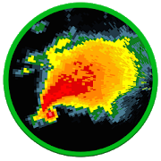
RadarCast - NOAA HD FutureCast 1.2
Stunning Past and FutureCast Radar Images, Snowfall,HurricaneTracks, Real-Time Lightning Strikes. See where storms,tornadoesand derechoes are expected to go! Plus see weatherforecast, severeweather warning boxes, storm direction arrows,hurricane forecasttracks and wildfires on the same map!Plus this is the only app that shows hi-definition animatedpast,current and future-radar in a single continuous sequence on afluidresponsive map without having to press a single button.Plus this is the only app that can instantly show predictedrainstart/stop times for any point on the map.Plus this is the only app that allows you to control theloopspeed, and also choose the interval between individual framesfrom5 minutes all the way to 1 hr, and also change the number offramesshown in animation.Plus this is the only app that automatically augmentsland-basedradar images with latest images from NOAA satellitescovering theAtlantic/Pacific oceans into one single screen. Thislets you trackand follow the upcoming hurricanes and storms allfrom the samemap.Plus easily bookmark multiple locations so you can do aquickradar + forecast check for all your important places in just afewseconds.- Install and go, no complex setup- RadarCast - our proprietary realtime future-cast technologythatlets you see hi-definition radar one hour into the future- Rain start/ stop times for any point on the map- Near real-time, shows the latest radar images within minutesofbeing gathered.- Severe weather warning boxes on the map- Storm Tracks on the map with detailed storm information- Hurricane Forecast Tracks on the map withdetailedinformation- Wildfire locations on map with detailed informationandfirefighting updates- Bookmark multiple locations for quick access- Check the current weather + forecast for any point onthemap- Fast Loading- Intuitive Play/pause/manual modes for moving betweenframes.- Always shows both time-stamp and "minutes ago" with each frametoprevent any confusion while viewing the loop- Select opacity of radar images to your taste- Read Area Forecast Discussions issued by your nearest NWSforecastoffice.- Check your local radar site's hardware operational statusfromwithin the app- See images from upto 6 hours ago by increasing frame intervalandnumber of frames to maximum- Portrait/Landscape/FullScreen- Get fast support from within the appCoverage Notes: If you live in a very-high-altitude towninColorado (e.g. Fraser, Vail, Aspen), most likely this app willnotmeet your needs since radar beams get blocked by thetallmountains. Alaska coverage includes only the southerncoastalareas, and does not include the Aleutian Chain. Cloudcoverage doesnot include Alaska and Guam. Also, push-notificationsfor rain willnot work reliably in Hawaii, Guam and Alaska. AviationSectionalCharts are not available for Hawaii.Notes:- This app is only useful for users in the US, including all50states and territories including Puerto Rico and Guam.


NOAA Weather International
Retrieve real-time 7-day hyperlocalpointweather forecasts and current weather conditions forworldwidelocations from NOAA NWS, Environment Canada & Dark Skybased onyour current location or any location in the world.Not only are NOAA forecasts the most accurate, they provideuniquepoint forecasts for every square mile which take intoconsiderationall the variables affecting the weather at that point,such asaltitude. This is especially useful in locations withhighlydynamic weather patterns and is a great tool forbeingoutdoors.-View forecast & current conditions for yourcurrentlocation.-View forecast & current conditions for any location intheworld by map.-Save favorite locations to quickly retrieve forecastsforthem.-Hourly forecast-Animated radar, cloud cover, precipitation & wind imageryoverGoogle Maps-Map measuring tool to measure distance and elevation-Hazardous weather alerts-Current conditions notification-Home screen widget-Light and Dark Material themes-Optimized for tablets-Android Wear supportIn-app purchase is available to remove ads.Please e-mail me below with any bug reports or featuresrequests.Thanks!

NOAA Weather
Get the most accurate and detailed weather, sourceddirectlyfromNOAA. Designed specially for the Android devices withauserfriendly interface and the ability to get theweatherinformationyou need. What features are exclusive to NOAAWeatherApp?-Exclusive Location finder which uses your current GPSlocationtoget nearest weather information automatically. -Exclusive3hourlyweather forecast for next 72 hours and 6 hourly forecastfornext 7days. -Exclusive Interactive Maps that show weatherandseasforecast patterns. -Exclusive weather graphshowingtoday'stemperature, maximum, minimum, humidity andrainfall.-Exclusive 24hour forecast graph to show visually theforecasttemperature,maximum, minimum, humidity and rainfall.-Exclusive 7day forecastgraph shows visually the forecast for theweek ahead.Get forecasttemperature, mean monthly maximum, meanmonthlyminimum, humidityand rainfall. -Exclusive celestialinformationfrom sunrise,sunset, moonrise, moonset to major andminor periodsinformationused by fishermen and hunters. -Exclusivemarineinformation ontides, seas and wind. -Only app to provideforecastsdiscussions.-Exclusive five different themes to choosefrom. Shownbelow isDefault theme, this is our favorite since itmakes theinformationhighly visible. RADARS: - View all the weatherradars topredictwhen rainfall will reach you. - Includes sectionradar thatshows awider range of the clouds with rain. - Nationalsatelliteimagerywith radar. - View radar images on a map tovisually seewhen therain will reach you. WEATHER MAPS: - Theinteractiveweather andwave forecast maps that show weather forecastpatternsfor US. -Includes forecast maps for: ● Maximum Temperature●MinimumTemperature ● Probability of Precipitation ● Hazards●Temperature● Dewpoint ● Wind Speed and Direction ● Wind Gust ●SkyCover ●Amount of Precipitation ● Snow Amount ● Wave Height●ApparentTemperature ● Relative Humidity NOAA Weather Appisdesigned withan intuitive interface and fully equipped with alltheweatherinformation you need in your pocket. FINAL NOTES:-ThisAppcontains weather information only about United StatesofAmericaand its territories. -The data is sourced from TheNationalOceanicand Atmospheric Administration (NOAA) and was notdevelopedorpublished by NOAA. Any questions, bugs orrecommendations shouldbesent to us support@weatherinfoapp.com orvisit usatwww.weatherinfoapp.com.


NOAA UHD Radar & NWS Alerts 1.1.40
NOAA UHD Radar & NWS Alerts presents thelatestHigh-definitiondoppler radar straight from the NationalWeatherService and NWSAlerts NOAA UHD Radar & NWS Alerts is afast,easy-to-use andbeautiful application that displays animatedNOAAweather radar andNWS Alerts around your current location,allowingyou to quicklysee what weather is coming your way. Theweather maphas thepinch/zoom capability which allows you tosmoothly zoom andpanaround the United States and see what theweather is likeanywhere.NOAA UHD Radar & NWS Alerts showsanimated weather andweatheralerts, so you can tell if rain isheaded toward or awayfrom you,and how fast. NOAA UHD Radar &NWS Alerts also providesevereweather alerts such as advisory,warning and specialweatherstatements! Download NOAA UHD Radar &NWS Alerts todayand tryit out! Features - Animated doppler radarover Google Maps-Forward or backward Radar image - Directly selectspecificTimeDoppler Radar Image - Smooth transition of position andzoom-Current NWS Weather Alerts with polygons - DetailNWSWeatherAlerts in beautiful bottom Sheet in the map. -WeatherLayers: Highdefinition doppler Radar - Severe Weather Layer:None,Fire,Floods, Fog, Freezing, Hurricane and Tropical,HurricaneandTropical Tracks, Ice, Snow, Storm and Tornados, Wind,WinterPleasee-mail me below with any bug reports or featuresrequests.Thanks!


NOAA Image Of The Day 1.2
Live wallpaper which displays the Image OfTheDay published by the National Oceanic andAtmosphericAdministration (NOAA) Environmental Visualization Lab.Each day a different glorious image is automaticallydownloadedand displayed as your wallpaper. NOAA NNVL images of thedayinclude stunning satellite imagery, fascinating graphsofenvironmental data, images of major worldwide weatherevents,etc.To install this animated wallpaper, launch the applicationiconor long-click on your phone's desktop, then select Wallpapers,thenselect Live wallpapers.

eWeather HD with Weather Radar
eWeather HD is the first app in the worldwithfuture radar, hurricane tracking, earthquakes and alertswidgets,geomagnetic storms and air quality, tides and buoyswidgetsand notifications.eWeather HD has a built-in barometer. A diagram isdisplayedwhich shows the atmospheric pressure changes for the past24 hours.A red warning display is produced when the barometerdetectschanges more than 0.2 inhg.The unique feature in this application is the“WeatherClock”. It provides all of the previous informationin anhour-by-hour clock format and is very interactive.Payment is one time, no ads, no any in-app payment, freeupdatessince 2010.Features:• Two world-renowned weather providers: Foreca andUSweather,• Future weather Radar based on NOAA radar and Google maps (TheUSAand Japan only) with 60 minutes radar prediction• Air quality and pollution in real time and forecast(forsome USA, UK, Europe and Asia cities)• Hurricane tracking• Tornado and Hail probability• Tides forecast• 365 days weather archive• Weather buoys: wave height, direction and period, wind andgust,pressure, water and air temperature, tides etc• Solstice, Equinox, Polar night, Polar day, Solar andLunareclipse• Sea surface temperature on weather map,widgets,notification area• Barometer with headache indicator• Map with radar, cloud satellite layer, sea and airtemperature,wind, alerts, hurricanes, humidity, earthquakesetc• Twenty original widgets of the weather, radar, time,moonphase, barometer, geomagnetic index, and UV index (1x1, 2x1,2x2,1x4, 4x1, 4x2, 3x3, 4x4, 5x2, 5x5 etc)• Radar widget on OpenStreetMap (for the USA and Japan only)• Ten-day forecast• Ten notification indicators in the status bar: temperature,moonphase, earthquakes, alerts, barometer etc,• Earthquakes widget on OpenStreetMap,• Weather Alerts (Advisory, Watch, or Warning) fromNOAA(National Oceanic and Atmospheric Administration);• Black ice and freeze warnings,• One-hundred latest earthquakes in the world on Google map• Pressure forecast graph• Moon phase, moon rise and moon set times• Sunrise and sunset times, time to sunrise or sunset• Duration of the day, day length changes• World map with weather alerts, weather, earthquakes andlocaltime• Geomagnetic storm forecast• Wind speed and directionality indicators• 15 KBytes of internet traffic per city for each weatherupdateonly• World clock• METAR from weather station (except Foreca)• UV index• Visibility on the roads• Dew point hour by hour graph• Precipitation probability• Precipitation amount: rainfall and newsnowfallamount• Follow by location (uses GPS or Cell Networklocationdetermination)• Full tablet support• Share forecast, alerts, earthquakes by e-mail andSMS• Alarm clock time on clock dial and grapheWeather HD provides information on the last earthquakesfromall over the world. View the latest earthquakes in a list oron amap. Provides information regarding magnitude, time anddistance.You can filter earthquakes by their magnitude anddistance from yourlocationAnnual archives of air temperature and sea for any cityinthe world allows you to choose the good time and place forthetravel. You can compare the weather in the current year withtheweather in the last year. Also, you can always have yourownopinion about the statements that has never was so cold, hot,wet,dry.If you have ANY questions, there is an FAQ section thattakesyou directly to the website. If your question is specific toyourcustomized set up, customer service is courteous,knowledgeable,willing and able to help with fast turn aroundtime.

Weather Timeline - Forecast
Weather Timeline is a simple weather appthatfocuses on summarising the next hour, the next 48 hours andthenext week so you don't have to. It presents the forecast inatimeline to help you quickly glance and digest the informationandhas a strong focus on color to outline the weather conditions.Theapp includes current weather alerts/warnings for yourchosenlocations and includes a time machine weather forecast so youcanlook at the forecast months, even years in advance or checkwhatthe weather was like several decades ago.---- WATCH FACE ----This app includes an interactive watch face, tap on the watchfaceto view different weather data.------------------------------Features:. Simple, elegant design. Bold use of color to increase legibility. Watch Face. Timeline forecast so you can easily glance attheinformation. Time machine forecasting to check the weather months/yearsinadvance. Local weather alerts front and centre. Multiple weather provider options. Great theme customisation options (choose colours). Easy to understand graphs and charts of temperature,rainetc.... Android wear support. Table layout. Multi language support. Powered by the hyperlocal weather service, Forecast(andothers)


NOAA Ocean Buoys 2.2
As featured on the Best Buy commercial -thisis the Wave Finding App!IF YOU DON'T SEE THE BUOY YOU WANT EMAIL US AND WE WILLADDIT!Don't forget we have a PRO version with Favorites and Tides!The NOAA Ocean Buoys application provides users with accesstolive data transmitted from over 120 buoys scatteredthroughoutNorth America, Alaska, Hawaii, Canada, Europe, and theCaribbean.Most buoys provide information about current waveheights, waveperiods, wind speed, wind direction, air temperature,watertemperature, atmospheric pressure, pressure tendency, anddewpoints. One of the best tools for professionals andgeneralenthusiasts alike.THIS APPLICATION IS PERFECT FOR:SurfersSailorsMarinersFishermanDiversWind surfersKite boardersKayakersLifeguardsBeach goersand anyone else looking to know current conditions of the oceansandbeaches near them.FINDING BUOYSUse our interactive Buoy Map to find see all availablebuoys,once you find the one you want - just click it and you willbe sentto the buoy details page. Or Buoys can be found based ontheirregion, buoys can also be searched for by their station Id’sorusing search terms that may describe their location, ie:NewJersey.BUOY LOCATIONSOver 120 buoy locations available. Buoys are available inthefollowing regions:East Coast U.SWest Coast U.SGulf Coast U.SGreat Lakes U.SHawaiiAlaskaEuropeCanadaCanadian MaritimesCaribbeanFor a detailed map of locations please visit: http://www.ndbc.noaa.gov/DATA AVAILABLEThere are many types of data available by buoys. Differentbuoysmay display different types of data depending upon their buoytypebut may include any of the following:Wave HeightsWave PeriodsSwell DirectionWind SpeedWind DirectionAir TemperatureWater TemperatureAtmospheric PressurePressure TendencyDew PointsData for buoys is provided by the National OceanicandAtmospheric Administration.★☆★☆★☆★☆★☆★☆★☆PRESS FOR NOAA Ocean Buoys“The official NOAA buoys are essential tools that prosurfersuse, and you should too. This app is definitely asteal.”– Surfer Magazine"’It's actually great for figuring out what's going on whenyouwake up in the dark and need figure out what's going on,withoutleaving your bed’ […] If the surf hasn't cleaned up yet, ortheswell hasn't arrived, no one wants to stumble out into a40-degreemorning […] It's also good for getting real time info totrack aswell, watching the numbers rise or fall.”– ESPN Surfing BlogThe app “processes countless data from NOAA’s buoys anddisplaysit in an easy-to-read format on your phone.”– Eastern Surf Magazine★☆★☆★☆★☆★☆★☆★☆

Storm Radar 1.5
The wait for Storm Radar is over!Highdefinition radar, advanced storm cell tracking, andreal-timesevere weather alerts make this the best app to have byyour sidewhen weather is closing in. View current conditions, dailyorhourly forecasts at a glance and in a more detailed view.Nowavailable free on Android.FEATURESINTERACTIVE MAP• Radar: The highest resolution (250m) radar showinginteractiveanimations for past and future data• Global Radar: An experimental radar layer with worldwidecoverage.It combines existing radar data with a computer modelproxy whendata is not available.• Storm Tracks: Storm Tracks utilize the most advancedsevereweather algorithms to provide a detailed analysis of animpendingstorm. This includes a storm strength rating, detailedcomponentsof the storm (such as wind, hail, lightning, andtornadoes), thespeed and direction of the storm, the precipitationrate, and muchmore.• Tropical Tracks map overlay• Lightning: View lightning 100 miles around your selectedlocation(Continental US only)• More: Full screen map with customizable data layersincluding:earthquakes, fronts, severe weather alerts, andmore.WIDGETS, ALERTS, & MORE!• Hyper-local weather data powered by Weather Underground'snetworkof over 250,000 personal weather stations• Widget featuring real-time alerts for severe weather• In-App alerts from the NOAA, Environment Canada,andMeteoAlarm.• Tap on current conditions, daily or hourly forecasts to viewmoredetailed weather data• Social weather: share storm tracking and radar data withyourfriends and family via text message, email, Facebook,orTwitter• Available on Android phones and 7-inch tablets.• Privacy policy can be foundat:http://www.wunderground.com/legal.asp?app=iOS_storm&vers=1.0#privacy• Terms of Use can be foundat:http://www.wunderground.com/legal.asp?app=iOS_storm&vers=1.0#terms

