
1.1.9 / Apr 19, 2023
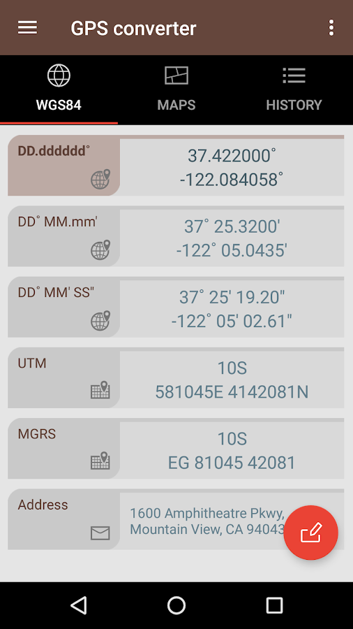
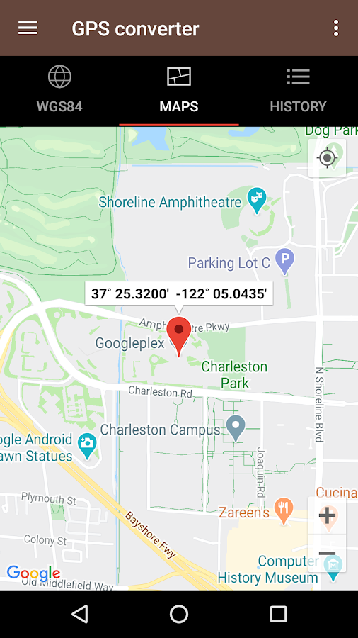


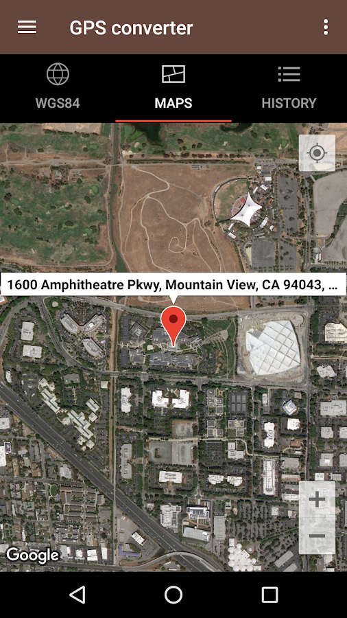
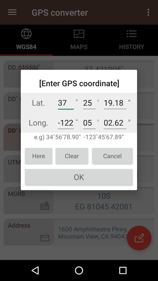

Description
App Information GPS coordinate converter
- App NameGPS coordinate converter
- Package Namekr.sira.gps
- UpdatedApr 19, 2023
- File SizeUndefined
- Requires AndroidAndroid 5.0
- Version1.1.9
- DeveloperSmart Tools co.
- Installs100K+
- PriceFree
- Categoryflag</i>Flag as inappropriate</a></div></section></div></div><div class="o45e4d"><c-wiz jsrenderer="Grlxwe" jsshadow jsdata="deferred-i18" data-p="%.@.true,true]" data-node-index="5;0" autoupdate jsmodel="hc6Ubd" c-wiz><section class="HcyOxe" jscontroller="NkbkFd"><header class=""><div class="VMq4uf" id="developer-contacts-heading"><div class="EaMWib"><h2 class="XfZNbf">Developer contact</h2></div><div jsaction="JIbuQc:Ptdedd"><button class="VfPpkd-Bz112c-LgbsSe yHy1rc eT1oJ mN1ivc VxpoF" jscontroller="soHxf" jsaction="click:cOuCgd; mousedown:UX7yZ; mouseup:lbsD7e; mouseenter:tfO1Yc; mouseleave:JywGue; touchstart:p6p2H; touchmove:FwuNnf; touchend:yfqBxc; touchcancel:JMtRjd; focus:AHmuwe; blur:O22p3e; contextmenu:mg9Pef;mlnRJb:fLiPzd;" data-disable-idom="true" aria-label="Expand" aria-controls="developer-contacts" aria-expanded="false"><div jsname="s3Eaab" class="VfPpkd-Bz112c-Jh9lGc"></div><div class="VfPpkd-Bz112c-J1Ukfc-LhBDec"></div><i class="google-material-icons VfPpkd-kBDsod W7A5Qb" aria-hidden="true">expand_more</i></button></div></div></header><div class="SfzRHd jqSImf" role="region" id="developer-contacts" aria-labelledby="developer-contacts-heading"><div class="vfQhrf BxIr0d"><div class="VfPpkd-WsjYwc VfPpkd-WsjYwc-OWXEXe-INsAgc KC1dQ Usd1Ac AaN0Dd VVmwY"><div class="VfPpkd-EScbFb-JIbuQc" jscontroller="tKHFxf" jsaction="click:cOuCgd; mousedown:UX7yZ; mouseup:lbsD7e; mouseenter:tfO1Yc; mouseleave:JywGue; touchstart:p6p2H; touchmove:FwuNnf; touchend:yfqBxc; touchcancel:JMtRjd; focus:AHmuwe; blur:O22p3e; contextmenu:mg9Pef;"><a class="Si6A0c RrSxVb" target="_blank" href="http://smart-tools.kr"><i class="google-material-icons j25Vu" aria-hidden="true">language</i><div class="pZ8Djf"><div class="xFVDSb">Website</div><div class="pSEeg">http://smart-tools.kr</div></div></a><div class="VfPpkd-FJ5hab"></div></div><span class="VfPpkd-BFbNVe-bF1uUb NZp2ef" aria-hidden="true">
- Developer12th floor, 126 Beomeocheon-ro, Suseong-gu, Daegu, Republic of KOREA
- Google Play Link
GPS coordinate converter Version History
Select GPS coordinate converter Version :-
GPS coordinate converter 1.1.8 APK File
Publish Date: 2023 /1/25Requires Android: Android 5.0+ (Lollipop, API: 21)File Size: 4.4 MBTested on: Android 12L (Snow Cone v2, API: 32)File Sha1: dc73ae146eb2a75beb3dd8ec988132e683df74b1
Smart Tools co. Show More...


Similar Apps Show More...


GPS Essentials APK
The most complete GPS tool available:Navigate, manage waypoints, tracks, routes, build your owndashboard from 45 widgets.❧❧❧❧❧ Dashboard ❧❧❧❧❧Shows navigation values such as: Accuracy, Altitude, Speed,Battery, Bearing, Climb, Course, Date, Declination, Distance, ETA,Latitude, Longitude, Max Speed, Min Speed, Actual Speed, TrueSpeed, Sunrise, Sunset, Moonset, Moonrise, Moon Phase, Target,Time, TTG, Turn.❧❧❧❧❧ Compass ❧❧❧❧❧Show the orientation of the earth's magnetic field, shows anarbitrary tracking angle and the current target. Also a marineorienteering compass.❧❧❧❧❧ Tracks ❧❧❧❧❧Record tracks and view them on map. Export KML files and importinto Google Maps, Google Earth and others.❧❧❧❧❧ Routes ❧❧❧❧❧Manage routes and view them on map. Import KML files from GoogleMaps, Google Earth and others. Create turn-by-turn instructionsbetween waypoints.❧❧❧❧❧ Camera ❧❧❧❧❧A camera HUD (heads-up display) view to show your waypoints, takepictures and share them.❧❧❧❧❧ Map ❧❧❧❧❧A map to show your waypoints. Convert mail addresses of yourcontacts to waypoint so that they can be used within the app.Supports Google Maps, MapQuest, OpenStreetMap and others.Supports Google Maps v2: Indoor Maps, Traffic, Buildings, Satelliteand Terrain layers and map rotation.❧❧❧❧❧ Waypoints ❧❧❧❧❧A list of all your waypoints with export and import (KML, KMZ, GPXand LOC format).❧❧❧❧❧ Satellites ❧❧❧❧❧A sky view of the current positions that shows satellites inview.❧❧❧❧❧ Features ❧❧❧❧❧Supported position formats: UTM, MGRS, OSGB, Degree-Minute-Second,Degree-Minute-Fractions, Decimal, Mils. Supports over 230datums.Waypoints, routes and tracks can be exported as KML or GPX filesand sent by email or uploaded to Google Docs or DropBox.Please open the web page below for more info, send me emails forsupport. I CANNOT HELP IF YOU SIMPLY PLACE A COMMENT HERE.Purchase the "GPS Essentials Donation Plugin" on Android Market ifyou want to support development.The latest beta release is available athttp://www.gpsessentials.com for download. Try out the latestfeatures and help us improve GPS Essentials!If you are on Facebook, come and join GPS Essentials for the latestinfo: http://www.gpsessentials.comTHIS APP WILL SHOW ADVERTISING. IF YOU DON'T LIKE THIS, PLEASEREFRAIN FROM INSTALLING/UPDATING.GPS Essentials is not affiliated with any political party nor withany other organization mentioned in the ads, and it has noconnection with any economic interests. If you don't like the ads,please contact AdMob.WHAT ARE THE PERMISSIONS GOOD FOR?✓ Coarse/Fine location: To access network locations and GPS✓ Full internet access: To read map tiles, send bug reports✓ Modify/delete USB storage contents: To write waypoints, tracksand images onto the SD card✓ Read phone state and identity: To tag pictures with the device ID(can be switched off in settings)✓ Take pictures and videos: Camera HUD, take pictures✓ Your accounts: Required to run Google Maps v2


Coordinator-Collect Coordinate 7.2.0 APK
Using Coordinator app, you can collect coordinate data from land onwhatever coordinate system you want, choosing from defined systems.You can use Google Maps or Here Maps as a basemap. You can collectGPS coordinates. You can use the app as a GPS tracker. You can viewa coordinate data on the map and also search by address and seethat on the map. You can get directions to that point. You cansearch by longitude/latitude. You can convert an existingcoordinate into another coordinate system. You can do this bytyping coordinates manually or opening an XLSX file which containscoordinates. You can display circumference and area measurements ofsome coordinates by opening the file which created before. Also youcan measure distance and area for some coordinates which determinedmanually on the map. You can display a KML file on the map. Thereis also a compass tool. Coordinator app contains several usefultools for people interested in coordinates, maps and geographicinformation systems (GIS). All of the features above are free. Onthe other hand if you become a Coordinator Pro subscriber, you canbenefit from many extra features in addition to these features.With Coordinator Pro, subscribers can use some extra features suchas Cloud Database Functions (creating points, lines & polygons,sharing your layers with teammates, working simultaneously withteammates, working offline and synchronizing, etc), exporting toKML & Excel files, making elevation & address querying andso on. It is ad-free. Besides longitude/latitude, subscribers canfind out the altitude value of a point on the Google Maps or HereMaps. You can search by address and so that locate it on the GoogleMaps and learn the GPS coordinate (longitude/latitude ornorthing/easting) value of this place. The address locating featureworks based on Google Maps services and it's very effective. If youare a subscriber, you can use the Coordinator Web app. So that youcan use the cloud database features of the Coordinator app on theweb page on your computer and monitor the data instantly. You canview/track and edit cloud database data on the web page. In thisway, you can instantly monitor the data movements made in themobile app in the field, in the web browser on your computer. Thecoordinate systems of the countries, which the app is mostdownloaded, are added to the app. Current list of the countries andtheir coordinate systems defined in this app: World - GPS(WGS 84)World - WGS 84 - 6 ̊ UTM United States - "NAD 1983 HARN State PlaneCoordinate Systems(meters & feet)" and "Military Grid ReferenceSystem (MGRS)" Algeria - "Nord Sahara 1959 / UTM 6 ̊ " Azerbaijan -"Pulkovo 1942 / Gauss-Kruger 3 ̊ " and "Pulkovo 1942 / CS63"Bulgaria - "Pulkovo 1942(58) GK 6 ̊ " Germany - "DHDN/3 ̊ GK" and"ETRS89 UTM 6 ̊" India - "Kalianpur 1975 / India" and "Kalianpur1975 / UTM 6 ̊" Indonesia - "Indonesia 1974 UTM 6 ̊" and "DGN 1995Indonesia TM3 ̊" Iran - "ED50(ED77) / UTM 6 ̊" Iraq - "Nahrwan 1967/ UTM 6 ̊" and "ED50 / Iraq National Grid" and "Karbala 1979 / UTM6 ̊" Israel - "Palestine 1923/Palest. Grid" and "Palestine1923/Israeli CS Grid" and "Israel 1993/Israeli TM Grid" Lebanon -"Deir ez Zor / Levant Ster." and "Deir ez Zor / Syria Lambert"Mauritania - "Mauritania 1999 / UTM 6 ̊" Morocco - "Merchich / NordMaroc" and "Merchich / Sud Maroc" Netherlands - "Amersfoort / RDNew" and "Amersfoort / RD Old" Palestine - "Palestine 1923/Palest.Grid" and "Palestine 1923/Israeli CS Grid" and "Israel 1993/IsraeliTM Grid" Philippines - "Luzon 1911 / Philippines" and "PRS92 /Philippines" Romania - "Dealul Piscului 1930 / Stereo 33" and"Pulkovo 1942(58) / Stereo 70" Russia - "Pulkovo 1942 /Gauss-Kruger 3 ̊" Saudi Arabia - "Ain el Abd / UTM 6 ̊" and "Ain elAbd / Aramco Lambert" Syria - "Deir ez Zor / Levant Ster." and"Deir ez Zor / Syria Lambert" Turkey - "ITRF 96 - 3 ̊" and "ED 50 -3 ̊" and "ITRF 96 - 6 ̊" and "ED 50 - 6 ̊" United Arab Emirates -"Nahrwan 1967 / UTM"


